Surveying
Boundary & Topographical Surveys
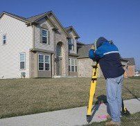
You can count on the professionals at Jim Hughes & Associates P.A. in Burnsville, North Carolina, to provide accurate boundary and topographical surveys for loan and insurance purposes.
Boundary Surveys
Determine proper property lines with boundary surveys from our land surveying
company. We survey any improvement, easement, or encroachments that may be on the partials of land, as described in your deed.
To get started, we need a copy of the deed for your property and adjoining properties. After a deed analysis, we come out to do the fieldwork, which includes location of property, monuments, improvements, and any encroachments. After this is complete, we produce and provide you with a boundary survey.
GET STARTED TODAY
Topographical Surveys
A topographical survey measures the elevation of points on a piece of land and presents them as contour lines on a map. The purpose of this type of survey is to gather data about the natural features of the land, as well as the elevation. Using this information, we prepare a three dimensional map, which is helpful for construction, building subdivisions, or any other type of earth moving.
Mortgage Surveys
When your bank or lender requires a survey for the mortgage, property, or new construction loan, let our professional land surveyors handle the job for you. We survey every inch of land and provide the proper documentation.
Flood Certificate Surveys
Sometimes a flood certificate is required to obtain insurance or a mortgage or construction loan on your house or property.
REQUEST A FREE ESTIMATE
Let us take a survey of your land and provide you with the certificate you need. Our calendar is scheduled a week in advance, so make your appointment fast!
To request an estimate for a boundary or topographical survey, contact us
in Burnsville, North Carolina.